ESA — VizLAB
DATA VISUALISATION
WEB PLATFORM
.png)
Photo Credits: mammaknowsmelbourne.com.au
Client: Exprivia
Project: Destination Earth (DestinE), European Space Agency
Role: UX/UI Designer & Prototyping Lead
Tech: Cesium.js, Angular
Year: 2023-2025
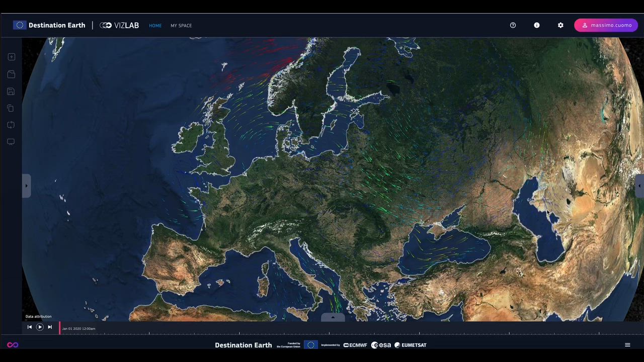
VizLab is a web-based data visualization environment developed for Destination Earth, ESA’s flagship program aimed at modeling and simulating the planet at unprecedented detail. Exprivia brought me in to shape the user experience, interface design, and interaction prototypes for a platform dealing with massive geospatial datasets.The goal: make climate-scale complexity feel navigable, intuitive, and even enjoyable. No pressure.
Challenge
DestinE isn’t your typical web dashboard. It needs to handle:2D, 3D, and 4D spatiotemporal dataHigh-resolution global simulationsMultiple data types and scientific formatsVarying device capabilities (mobile → high-end workstations)Interoperability with the wider DestinE ecosystemThe problem: scientists need depth; the public needs clarity. My job was to bridge both worlds without turning the interface into a cockpit.
My Contribution
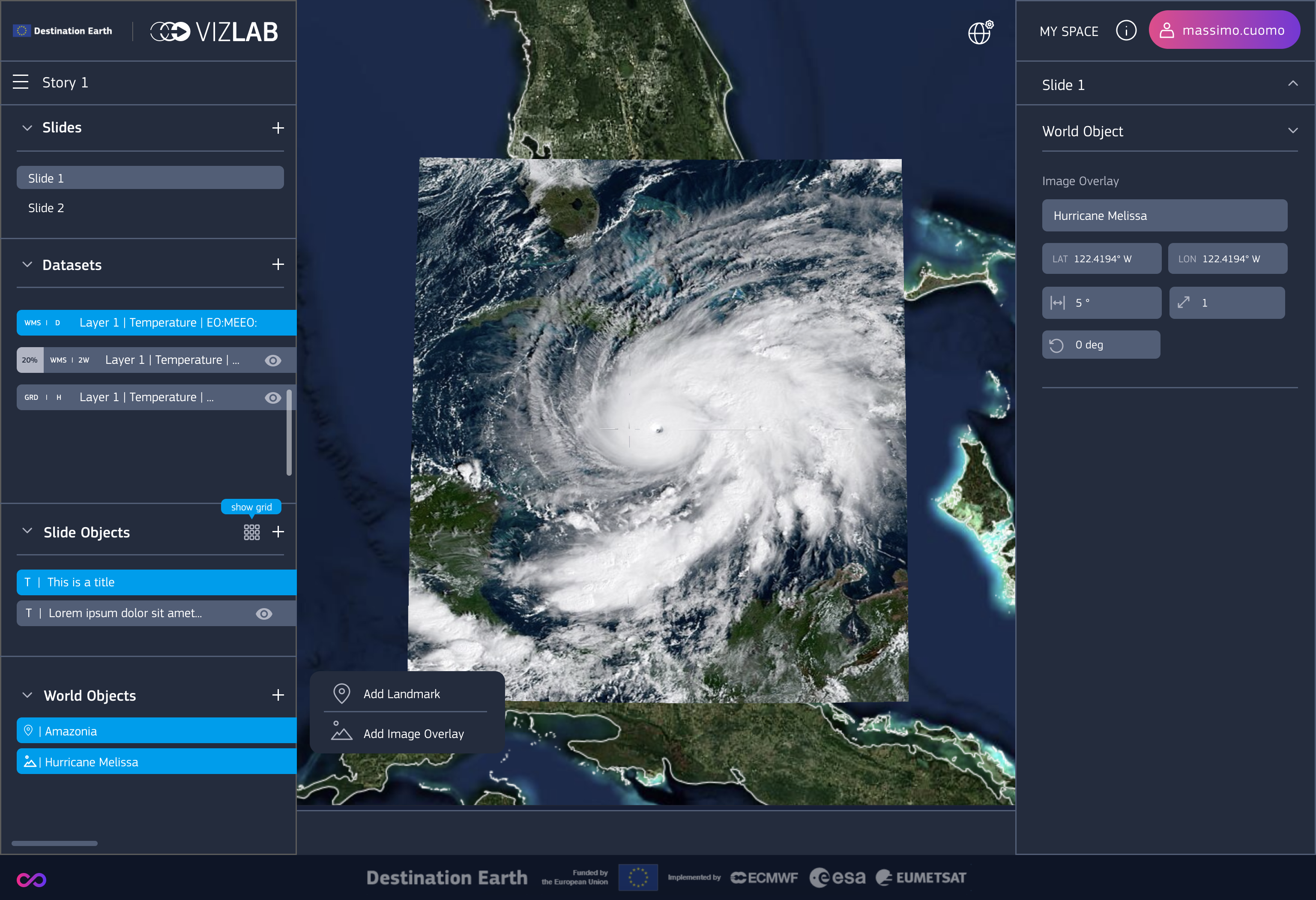
I led the UX/UI direction and built functional prototypes to define how users navigate and manipulate complex datasets.
UX Architecture:
Defined user flows for dataset selection, layer management, temporal navigation, and scenario comparison.
UI Design:
Designed a clean, modular interface focused on clarity and responsiveness—keeping cognitive load low even when the data becomes heavy.
Cesium.js Interaction Prototyping:
Created working prototypes that tested camera behaviors, 3D interactions, temporal scrubbing, and geospatial overlays.
User-Centric Approach:
Made scientific data accessible to a broader audience through intuitive affordances, simplified controls, and clear visual hierarchy.
Result
VizLab now serves as a storytelling engine for planetary-scale data—letting users explore climate scenarios, environmental changes, and geospatial intelligence through a seamless and immersive interface.
Smooth navigation of massive datasets
Consistent UX across user journeys
Fast learning curve for non-experts
Strong alignment with ESA’s mission for public accessibility
What This Project Shows
Mastery of UX/UI for complex scientific and technical applications
Experience designing for 3D geospatial ecosystems (Cesium.js)
Ability to translate highly technical requirements into human-friendly interfaces
Collaboration with large, multi-partner European projects
Rigorous prototyping and system-thinking skills
Project: Destination Earth (DestinE), European Space Agency
Role: UX/UI Designer & Prototyping Lead
Tech: Cesium.js, Angular
Year: 2023-2025
VizLab is a web-based data visualization environment developed for Destination Earth, ESA’s flagship program aimed at modeling and simulating the planet at unprecedented detail. Exprivia brought me in to shape the user experience, interface design, and interaction prototypes for a platform dealing with massive geospatial datasets.The goal: make climate-scale complexity feel navigable, intuitive, and even enjoyable. No pressure.
Challenge
DestinE isn’t your typical web dashboard. It needs to handle:2D, 3D, and 4D spatiotemporal dataHigh-resolution global simulationsMultiple data types and scientific formatsVarying device capabilities (mobile → high-end workstations)Interoperability with the wider DestinE ecosystemThe problem: scientists need depth; the public needs clarity. My job was to bridge both worlds without turning the interface into a cockpit.
My Contribution
I led the UX/UI direction and built functional prototypes to define how users navigate and manipulate complex datasets.
UX Architecture:
Defined user flows for dataset selection, layer management, temporal navigation, and scenario comparison.
UI Design:
Designed a clean, modular interface focused on clarity and responsiveness—keeping cognitive load low even when the data becomes heavy.
Cesium.js Interaction Prototyping:
Created working prototypes that tested camera behaviors, 3D interactions, temporal scrubbing, and geospatial overlays.
User-Centric Approach:
Made scientific data accessible to a broader audience through intuitive affordances, simplified controls, and clear visual hierarchy.
Result
VizLab now serves as a storytelling engine for planetary-scale data—letting users explore climate scenarios, environmental changes, and geospatial intelligence through a seamless and immersive interface.
Smooth navigation of massive datasets
Consistent UX across user journeys
Fast learning curve for non-experts
Strong alignment with ESA’s mission for public accessibility
What This Project Shows
Mastery of UX/UI for complex scientific and technical applications
Experience designing for 3D geospatial ecosystems (Cesium.js)
Ability to translate highly technical requirements into human-friendly interfaces
Collaboration with large, multi-partner European projects
Rigorous prototyping and system-thinking skills
.png)
.png) ← HOME← ALL PROJECTSNEXT PROJECT →
← HOME← ALL PROJECTSNEXT PROJECT →